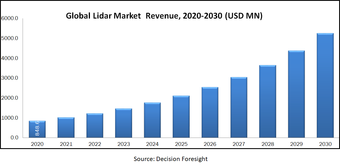
LiDAR Market is estimated 848.64 million USD in 2020 and is anticipated to reach 5254.5701 million USD by 2030 to grow at a CAGR of 20% during the forecast period owing to its applications in meteorology, cartography, urban planning, and exploration, driverless cars, advanced driver assistant systems, engineering, and corridor mapping. LiDAR (Light Detection and Ranging) is a remote sensing methodology applied to discover the information regarding an object by emitting light towards the object and measure the distance of target, from the reflected light using a sensor. Ground based LiDAR systems is envisaged to account a major share during the forecast timeline attributed to the factors such as low cost and growing applications in SUV (Sport Utility Vehicle). Ground LiDAR generates 3-D images of land and ground movements, particularly landslides and it can be examined and evaluated by satellite images. Moreover, EERI (Earthquake Engineering Research Institute) partnered with GEER (Geotechnical Extreme Events Reconnaissance) employs ground based LiDAR to gather damage data during earthquake, at high speed coupled with high level of accuracy significantly foster the market growth. Solid state LiDAR technology is attaining momentum among automobile manufacturers around the globe by virtue of its speed and cost effectiveness over conventional LiDAR solutions. Exploitation of solid state technology reduces the cost of a single LiDAR unit below 100 USD further leading to market progression.
Market Segmentation:
On the basis of product, global LiDAR market is classifies into airborne, unmanned aerial vehicle, and terrestrial. On the basis of component, LiDAR market is categorized into laser scanner, GPS receiver, inertia measurement unit high precision clock, and others. By application, the market is grouped into corridor mapping, coastal, forestry, defense & aerospace, flood mapping, transportation, transmission lines, infrastructure, driverless cars, exploration & meteorology, and cartography. Geographic breakdown and analysis of each of the aforesaid segments includes regions comprising North America, Europe, Asia-Pacific, and RoW.
Market Dynamics and Factors:
Rising demand for 3-D imagery in various industry verticals especially power transmission, construction, aerospace, transportation and defense is positively influencing the global LiDAR market development. Well-structured 3-D imagery is applied in several applications such as city planning, 3-D mapping and photo realistic fly. Escalating adoption for aerial LiDAR systems to discover and research historical evidences and various places coupled with increasing usage of drone’s different verticals namely agriculture, forestry, aerospace, defense and natural resource management is expected to propel the market growth in forecast timeline. Additionally, LiDAR systems possess time and cost saving abilities which further increased its adoption rates. Governments in various nations are utilizing LiDAR technology for mapping, topological surveys, monitoring and surveillance of mining in oil and gas industries owing to the low cost and improved features of LiDAR technology over traditional mapping methods. Furthermore, LiDAR technology substituted photogrammetry owing to its merits over photogrammetry in terms of high accuracy and light independency. However, high degree of difficulty for data interpretation in LiDAR systems attributed to the lack of standardization is negatively influencing the market growth. Lack of awareness regarding the benefits of LiDAR technology among end users coupled with the high cost of LiDAR systems due to the usage of costly components especially 3-D cameras, navigation systems, and laser scanners are inhibiting the market growth. Global LiDAR market for ADAS (Advanced Driver Assistant System) and driverless cars is anticipated to grow at an aggressive rate in virtue of the rising desire towards self-driven cars further leads to the market growth in near future. Rising number of electrical companies resulted in the increased demand for LiDAR technology in power sector, for setting up and laying out transmission lines and is envisaged to boost the market progression in coming years.
Geographic Analysis:
North America dominates in the global LiDAR market attributed to the increasing demand for 3-D imaging technology in Canada and the U.S. Huge investments of companies such as Google Inc, Apple Inc, and General Motors towards driverless cars and ADAS also helps LiDAR technology to be a lucrative market in North America. Exploitation of LiDAR in defense and military sectors also act as catalyst for the market growth in this region. Asia Pacific is the fastest growing region due to the presence of emerging countries such as India, China and Japan.
Competitive Scenario:
The major key players in global LIDAR market are Hexagon AB, Trimble Inc., Riegl Laser Measurement Systems GMBH, Faro Technologies, Geokno India Pvt. Ltd, Teledyne Technologies, Inc, YellowScan, Quantum Spatial, Inc, Sick AG, Velodyne LiDAR, Optech Incorporated, Quanergy LiDAR, Leica Geoystems, DENSO Corporation, and Neptec Technologies Corp.
Lidar Market Report Scope
| Report Attribute | Details |
| Market size value in 2020 | USD 848.64 million |
| Growth Rate | CAGR of 22% from 2021 to 2030 |
| Forecast period | 2021 - 2030 |
| Quantitative units | Revenue in USD billion 2020 to 2030 and CAGR from 2021 to 2030 |
| Report coverage | Revenue forecast, Market Share Analysis, Sales Analysis, Competitor Analysis, Growth factors, and trends, Macro-economic indicator analysis, PORTER's Five Forces analysis, Pricing Analysis, PESTEL Analysis, Value Chain Analysis, COVID-19 Impact Analysis |
| Segments covered | By Product (Airborne [Topographic And Bathymetric], UAV (Unmanned Aerial Vehicle), And Terrestrial [Mobile And Static]), By Component (Laser Scanner, GPS Receiver, Inertia Measurement Unit, High Precision Clock, And Others), By Application (Corridor Mapping, Coastal, Forestry, Defense & Aerospace, Flood Mapping, Transportation, Transmission Lines, Infrastructure, Driverless Cars, Exploration & Meteorology, and Cartography) |
| Regional scope | North America; Europe; Asia Pacific; Latin America; MEA |
| Key Country scope | U.S.; Canada; Mexico; U.K.; Germany; France; Italy; Spain; Japan; China; India; Malaysia; Singapore; South Korea; Brazil; Argentina; South Africa; Saudi Arabia; UAE; Turkey |
| Key companies profiled | o Hexagon AB o Trimble Inc. o Riegl Laser Measurement Systems GMBH o Faro Technologies o Geokno India Pvt. Ltd o Teledyne Technologies, Inc o YellowScan o Quantum Spatial, Inc o Sick AG o Velodyne LiDAR o Optech Incorporated o Quanergy LiDAR o Leica Geoystems o DENSO Corporation o Neptec Technologies Corp. |